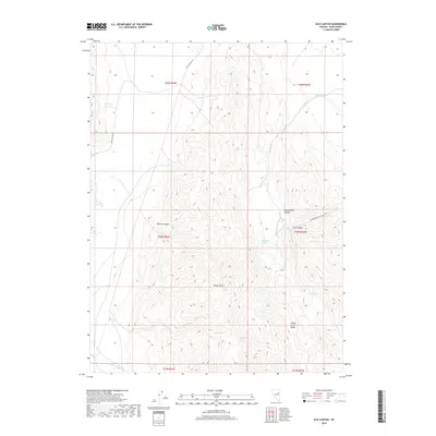
2018 Map of Silo Canyon
USGS Topo · Published 2018About this map
The Cherry Creek Range dominates this portion of Elko County, where high-elevation ridgelines culminate at Rocky Point. This landscape is defined by its drainage systems and natural water sources, essential for ranching and wildlife in the Great Basin. Deep incisions like Denton Canyon, Cottonwood Canyon, and the eponymous Silo Canyon channel seasonal runoff from the peaks. These canyons are dotted with vital water points such as Silo Spring, Augustine Spring, and Mustang Spring.
Find a feature on this map
21 named features on this map. Tap any name to fly to it.
Don’t see what you’re looking for? This feature index may not catch every label — zoom into the map to look around manually.
Map Details
Editions of this 2018 Silo Canyon Map
This is the sole edition of this map. No revisions or reprints were ever made.
Other maps of this area

1955 · Elko
USGS Topo · 1:250,000

1958 · Elko
USGS Topo · 1:250,000

1962 · Elko
USGS Topo · 1:250,000

1965 · Elko
USGS Topo · 1:250,000

1984 · Currie Gardens
USGS Topo · 1:24,000
1984 · Mt. Taylor
USGS Topo · 1:24,000

1984 · Silo Canyon
USGS Topo · 1:24,000
1984 · McDermid Ranch
USGS Topo · 1:24,000

1984 · Delcer Buttes
USGS Topo · 1:24,000
1984 · Palomino Well
USGS Topo · 1:24,000