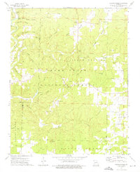
1973 Map of Siloam Springs
USGS Topo · Published 1976About this map
The Mark Twain National Forest dominates the topography of this section of the Ozarks during the early 1970s, where the rugged terrain is carved by complex drainage networks like Moss Hollow and Kenyon Hollow. Small communities and family landmarks are concentrated along the boundary between Douglas and Howell counties, including the settlement of Roosevelt and several rural churches and burial grounds. Geologic and industrial features are notably mapped, from the Tabor Cave near Tabor Hollow to a legacy Steam Mill located along the banks of Spring Creek. The presence of the Siloam Lookout Tower reflects the mid-century forest management of the era, while the namesake mineral waters of Siloam Springs remain a focal point of the local landscape alongside numerous smaller springs such as Smallpox Spring and Rattlesnake Spring.
Find a feature on this map
46 named features on this map. Tap any name to fly to it.
Don’t see what you’re looking for? This feature index may not catch every label — zoom into the map to look around manually.
Map Details
Editions of this 1973 Siloam Springs Map
This is the sole edition of this map. No revisions or reprints were ever made.
Other maps of this area

1939 · Topaz
USGS Topo · 1:62,500

1941 · Topaz
USGS Topo · 1:62,500

1944 · West Plains
USGS Topo · 1:62,500

1944 · Cureall
USGS Topo · 1:62,500

1945 · Harrison
USGS Topo · 1:250,000

1945 · Willow Springs
USGS Topo · 1:62,500

1946 · West Plains
USGS Topo · 1:62,500

1946 · Cureall
USGS Topo · 1:62,500

1948 · Willow Springs
USGS Topo · 1:62,500

1949 · Harrison
USGS Topo · 1:250,000