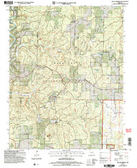
2004 Map of Siloam Springs
USGS Topo · Published 2006About this map
Siloam Springs and the surrounding Ozark woodlands of the Mark Twain National Forest are documented in this 2004 revision, which captures a landscape defined by its subterranean hydrology and early Missouri settlements. The area across the Douglas Co and Howell Co line is dotted with numerous groundwater outlets, including Still Spring, Wolf Spring, and the curiously named Smallpox Spring.
Find a feature on this map
40 named features on this map. Tap any name to fly to it.
Don’t see what you’re looking for? This feature index may not catch every label — zoom into the map to look around manually.
Map Details
Editions of this 2004 Siloam Springs Map
This is the sole edition of this map. No revisions or reprints were ever made.
Other maps of this area

1939 · Topaz
USGS Topo · 1:62,500

1941 · Topaz
USGS Topo · 1:62,500

1944 · West Plains
USGS Topo · 1:62,500

1944 · Cureall
USGS Topo · 1:62,500

1945 · Harrison
USGS Topo · 1:250,000

1945 · Willow Springs
USGS Topo · 1:62,500

1946 · West Plains
USGS Topo · 1:62,500

1946 · Cureall
USGS Topo · 1:62,500

1948 · Willow Springs
USGS Topo · 1:62,500

1949 · Harrison
USGS Topo · 1:250,000