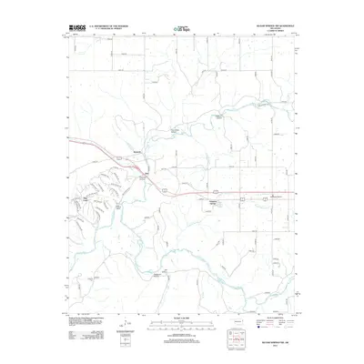
2012 Map of Siloam Springs NW
USGS Topo · Published 2012About this map
The Illinois River meanders through the southern half of this landscape, carving deep relief into the terrain as evidenced by the series of named hollows such as Tahlequah Hollow, Kill Hollow, and Fivemile Hollow. This 2012 survey captures a rural Oklahoma setting where traditional agricultural patterns on Moseley Prairie meet the winding river corridors. Small, established settlements like Dripping Springs, Flint, and Beckwith are connected by an extensive network of county roads, with US Route 412 serving as the primary east-west artery.
Find a feature on this map
85 named features on this map. Tap any name to fly to it.
Don’t see what you’re looking for? This feature index may not catch every label — zoom into the map to look around manually.
Map Details
Editions of this 2012 Siloam Springs NW Map
This is the sole edition of this map. No revisions or reprints were ever made.
Other maps of this area

1899 · Siloam Springs
USGS Topo · 1:125,000

1903 · Siloam Springs
USGS Topo · 1:125,000

1904 · Siloam Springs
USGS Topo · 1:125,000

1954 · Tulsa
USGS Topo · 1:250,000

1958 · Tulsa
USGS Topo · 1:250,000

1963 · Tulsa
USGS Topo · 1:250,000

1971 · Jay SE
USGS Topo · 1:24,000
1971 · Cherokee City
USGS Topo · 1:24,000
1971 · Colcord
USGS Topo · 1:24,000
1972 · Chance
USGS Topo · 1:24,000