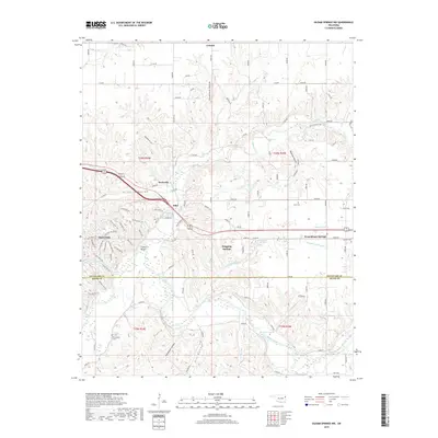
2019 Map of Siloam Springs NW
USGS Topo · Published 2019About this map
West Siloam Springs and the surrounding borderlands of the Oklahoma-Arkansas line are defined here by a winding network of river valleys and historical settlements. The topography is shaped by the Illinois River as it moves through the southern reach of the map, carving deep depressions such as Kill Hollow and Tahlequah Hollow. To the north, the community of Colcord sits amidst a plateau landscape that transitions into the unique terrain of Moseley Prairie. Local history is anchored by long-standing landmarks including Allen Cem, Crittenden Cem, and Johnson Cem. The map illustrates a rural transport system where contemporary county roads trace the paths of older routes through Fivemile Hollow and Calunchety Hollow, connecting small communities like Flint and Beckwith that have persisted through the modern era.
Find a feature on this map
111 named features on this map. Tap any name to fly to it.
Don’t see what you’re looking for? This feature index may not catch every label — zoom into the map to look around manually.
Map Details
Editions of this 2019 Siloam Springs NW Map
This is the sole edition of this map. No revisions or reprints were ever made.
Other maps of this area

1899 · Siloam Springs
USGS Topo · 1:125,000

1903 · Siloam Springs
USGS Topo · 1:125,000

1904 · Siloam Springs
USGS Topo · 1:125,000

1954 · Tulsa
USGS Topo · 1:250,000

1958 · Tulsa
USGS Topo · 1:250,000

1963 · Tulsa
USGS Topo · 1:250,000

1971 · Jay SE
USGS Topo · 1:24,000
1971 · Cherokee City
USGS Topo · 1:24,000
1971 · Colcord
USGS Topo · 1:24,000
1972 · Chance
USGS Topo · 1:24,000