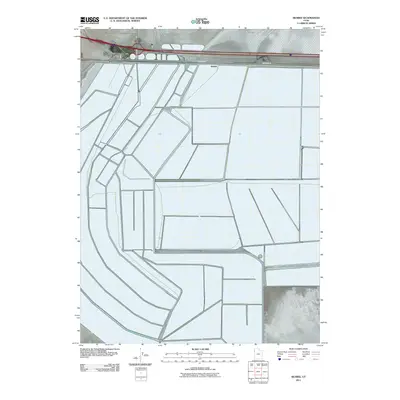
2011 Map of Silsbee
USGS Topo · Published 2011About this map
Bonneville Racetrack dominates the northern landscape of this Tooele County region, where the vast salt flats facilitate world-renowned speed trials. The map details the infrastructure surrounding this unique environment, including the International Racetrack and Frontage Rd running parallel to the interstate corridor. Near the salt's edge, the small settlements of Blair and Silsbee sit along the transit lines that connect this remote stretch of Utah to the Nevada border. The geometric precision of the irrigation and drainage networks south of the highway suggests a highly managed landscape, contrasting with the open expanse of the salt flats to the north. Travel and transport are the primary features here, evidenced by the path of Pilot Peak Rd as it moves toward the mountain ranges beyond the flats.
Find a feature on this map
6 named features on this map. Tap any name to fly to it.
Don’t see what you’re looking for? This feature index may not catch every label — zoom into the map to look around manually.
Map Details
Editions of this 2011 Silsbee Map
This is the sole edition of this map. No revisions or reprints were ever made.
Other maps of this area

1953 · Tooele
USGS Topo · 1:250,000

1955 · Tooele
USGS Topo · 1:250,000

1955 · Elko
USGS Topo · 1:250,000

1958 · Elko
USGS Topo · 1:250,000

1962 · Elko
USGS Topo · 1:250,000

1965 · Elko
USGS Topo · 1:250,000

1971 · Leppy Peak
USGS Topo · 1:24,000

1971 · Tetzlaff Peak
USGS Topo · 1:24,000

1971 · Bonneville Racetrack
USGS Topo · 1:24,000
1972 · Wendover
USGS Topo · 1:24,000