
1971 Map of Leppy Peak
USGS Topo · Published 1974About this map
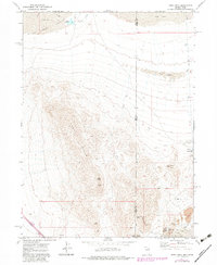
The Leppy Hills rise sharply above the Pilot Creek Valley in this early 1970s survey of the Nevada and Utah borderlands. Centered on the prominent Leppy Peak, the landscape is a complex of high ridges and significant geological formations, including the archeologically notable Danger Cave State Park. The map documents a network of Jeep Trails navigating the desert terrain, connecting landmarks like Bear Claw Tower and Needle Point to more remote sites such as Jukebox Cave and Limestone Cave. Cultural features are largely centered on infrastructure, with a Radio Facility Tower and Radio Towers Gas Tank & Spot near Wendover Peak. Hydrological data includes the Leppy Reservoir and the drainage of Pilot Creek through areas marked by extensive Sand Dunes. This record captures the high-desert border region before modern expansion, highlighting the intersection of prehistoric sites and twentieth-century telecommunications infrastructure.
Find a feature on this map
25 named features on this map. Tap any name to fly to it.
Don’t see what you’re looking for? This feature index may not catch every label — zoom into the map to look around manually.
Map Details
Editions of this 1971 Leppy Peak Map
2 editions found
Other maps of this area

1953 · Tooele
USGS Topo · 1:250,000

1955 · Tooele
USGS Topo · 1:250,000

1955 · Elko
USGS Topo · 1:250,000

1958 · Elko
USGS Topo · 1:250,000

1962 · Elko
USGS Topo · 1:250,000

1965 · Elko
USGS Topo · 1:250,000

1971 · Silver Island Pass
USGS Topo · 1:24,000
1971 · Miners Canyon
USGS Topo · 1:24,000

1971 · Pilot
USGS Topo · 1:24,000
1971 · Leppy Peak NW
USGS Topo · 1:24,000