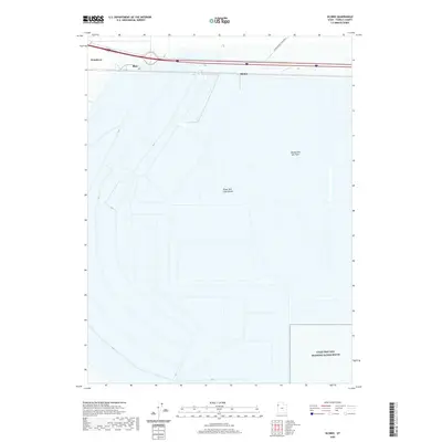
2020 Map of Silsbee
USGS Topo · Published 2020About this map
The Bonneville Salt Flats dominate this landscape within the larger Great Salt Lake Desert in Tooele County. This region is world-renowned for its unique geology, which provides the flat, hardened surface necessary for the International Racetrack located in the northern portion of the map. Settlement is concentrated along the western edge near Wendover, while smaller named locales such as Blair and Silsbee mark points along the primary transportation corridor that traverses the salt crust. The map illustrates the stark geography of the basin, where the interstate and rail lines cut a straight path across the expansive white terrain, highlighting the area's role as a critical transit point between the salt flats and the more rugged mountains to the west.
Find a feature on this map
6 named features on this map. Tap any name to fly to it.
Don’t see what you’re looking for? This feature index may not catch every label — zoom into the map to look around manually.
Map Details
Editions of this 2020 Silsbee Map
This is the sole edition of this map. No revisions or reprints were ever made.
Other maps of this area

1953 · Tooele
USGS Topo · 1:250,000

1955 · Tooele
USGS Topo · 1:250,000

1955 · Elko
USGS Topo · 1:250,000

1958 · Elko
USGS Topo · 1:250,000

1962 · Elko
USGS Topo · 1:250,000

1965 · Elko
USGS Topo · 1:250,000

1971 · Leppy Peak
USGS Topo · 1:24,000

1971 · Tetzlaff Peak
USGS Topo · 1:24,000

1971 · Bonneville Racetrack
USGS Topo · 1:24,000
1972 · Wendover
USGS Topo · 1:24,000