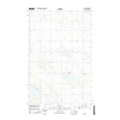
2014 Map of Silva
USGS Topo · Published 2014About this map
Silva sits at the heart of this Pierce County landscape, defined by a sparse network of section-line roads and numerous prairie potholes and wetlands typical of the region. This 2014 survey captures the rural character of the area, where the tiny settlement of Silva is flanked by agricultural fields and water bodies. To the southeast of the town site, the Trinity Cem serves as a significant local landmark for genealogical research, marking a generational connection to the land. The primary transportation artery is ND-3, which cuts through the western portion of the quadrangle, while CR-3526 provides east-west access through the center. The map reveals the intricate drainage patterns and small lakes that dot the landscape between 57th St and 50th St NE.
Find a feature on this map
22 named features on this map. Tap any name to fly to it.
Don’t see what you’re looking for? This feature index may not catch every label — zoom into the map to look around manually.
Map Details
Editions of this 2014 Silva Map
This is the sole edition of this map. No revisions or reprints were ever made.
Other maps of this area

1953 · Devils Lake
USGS Topo · 1:250,000

1954 · Tunbridge
USGS Topo · 1:24,000

1954 · Minot
USGS Topo · 1:250,000

1955 · Rugby
USGS Topo · 1:24,000

1956 · Devils Lake
USGS Topo · 1:250,000

1958 · Minot
USGS Topo · 1:250,000

1958 · Balta SE
USGS Topo · 1:24,000

1958 · Fillmore
USGS Topo · 1:24,000

1958 · Balta
USGS Topo · 1:24,000
1958 · Silva
USGS Topo · 1:24,000