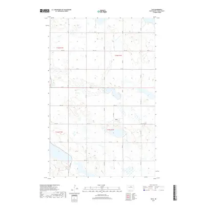
2017 Map of Silva
USGS Topo · Published 2017About this map
Silva sits as a central point of reference in this portion of Pierce County, surrounded by a prairie landscape defined by numerous small wetlands and depressions. The settlement pattern follows the established section lines of the Public Land Survey System, with a grid of rural routes such as 57th St and 30th Ave facilitating travel between farmsteads. A key historical landmark for the local community is Trinity Cem, located east of the main cluster of buildings in Silva. The land is divided into several townships, including t155n r72w and t154n r72w, reflecting the systematic agricultural development of the North Dakota plains. The density of intermittent water bodies suggests a region prone to seasonal changes in hydrology, shaping the way residents have managed the land since the late 19th-century settlement era.
Find a feature on this map
25 named features on this map. Tap any name to fly to it.
Don’t see what you’re looking for? This feature index may not catch every label — zoom into the map to look around manually.
Map Details
Editions of this 2017 Silva Map
This is the sole edition of this map. No revisions or reprints were ever made.
Other maps of this area

1953 · Devils Lake
USGS Topo · 1:250,000

1954 · Tunbridge
USGS Topo · 1:24,000

1954 · Minot
USGS Topo · 1:250,000

1955 · Rugby
USGS Topo · 1:24,000

1956 · Devils Lake
USGS Topo · 1:250,000

1958 · Minot
USGS Topo · 1:250,000

1958 · Balta SE
USGS Topo · 1:24,000

1958 · Fillmore
USGS Topo · 1:24,000

1958 · Balta
USGS Topo · 1:24,000
1958 · Silva
USGS Topo · 1:24,000