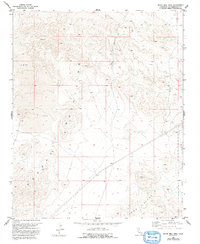
1993 Map of Silver Bell Mine
USGS Topo · Published 1993About this map
Mining exploration and military training intersect in this arid stretch of San Bernardino County, which was updated by the Department of the Interior in the early 1990s. The eponymous Silver Bell Mine sits on the eastern slopes of the unnamed Mountains that dominate the center of the sheet, surrounded by several smaller prospects and an isolated Prospect x. This mineral-rich landscape is defined by extensive Lava beds and volcanic features like the Cinder Pit to the west.
Find a feature on this map
11 named features on this map. Tap any name to fly to it.
Don’t see what you’re looking for? This feature index may not catch every label — zoom into the map to look around manually.
Map Details
Editions of this 1993 Silver Bell Mine Map
This is the sole edition of this map. No revisions or reprints were ever made.
Other maps of this area

1953 · San Bernardino
USGS Topo · 1:250,000

1954 · Galway Lake
USGS Topo · 1:24,000

1955 · Silver Bell Mine
USGS Topo · 1:24,000

1955 · Sunshine Peak
USGS Topo · 1:24,000

1955 · Newberry
USGS Topo · 1:62,500

1955 · Lavic
USGS Topo · 1:62,500

1955 · Cady Mountains
USGS Topo · 1:62,500

1955 · Rodman Mountains
USGS Topo · 1:62,500

1956 · San Bernardino
USGS Topo · 1:250,000

1957 · San Bernardino
USGS Topo · 1:250,000