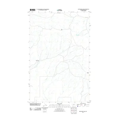
2011 Map of Silver Bow Lake
USGS Topo · Published 2011About this map
Thirtymile Creek and its complex drainage network define this northern Montana landscape in Blaine County. The terrain is shaped by the elevation of Cherry Ridge to the north and the prominent peaks of West Butte and Middle Butte to the east. Water management in this arid environment is evidenced by the Baird Reservoir Number 1 Dam, which sits along the Northwest Fork Thirtymile Creek. The eponymous Silver Bow Lake is situated in the northeastern portion of the quadrangle, feeding into Woody Island Creek. This 2011 survey documents a sparsely populated ranching or grazing region, where Cherry Ridge Rd provides one of the few primary points of access through the northern breaks and coulees.
Find a feature on this map
10 named features on this map. Tap any name to fly to it.
Don’t see what you’re looking for? This feature index may not catch every label — zoom into the map to look around manually.
Map Details
Editions of this 2011 Silver Bow Lake Map
This is the sole edition of this map. No revisions or reprints were ever made.
Other maps of this area

1904 · Chinook
USGS Topo · 1:62,500

1905 · Harlem
USGS Topo · 1:62,500

1912 · Zurich
USGS Topo · 1:125,000

1913 · Cherry Ridge
USGS Topo · 1:125,000

1953 · Havre
USGS Topo · 1:250,000

1957 · Havre
USGS Topo · 1:250,000

1958 · Havre
USGS Topo · 1:250,000

1984 · Richmond Reservoir
USGS Topo · 1:24,000
1984 · Harlem NW
USGS Topo · 1:24,000
1984 · Silver Bow Lake
USGS Topo · 1:24,000