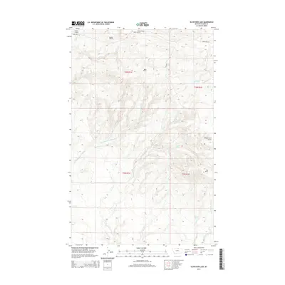
2014 Map of Silver Bow Lake
USGS Topo · Published 2014About this map
West Butte and Mid Butte dominate this northern Montana landscape, rising above the surrounding plains of Blaine County. The region is defined by a network of seasonal watercourses and drainages, including the Northwest Fork Thirtymile Cr and the E Br Thirtymile Cr, which carve through the territory south of Cherry Ridge. This area shows the intersection of natural springs and ranching infrastructure, where water sources like Gidley Spring, Laporte Spring, and Campbell Spring provide critical resources in an arid environment. The map details the local road system, specifically Cherry Ridge Rd and Frigo Rd, which navigate the high ground and connect the isolated basins. Evidence of land use is visible in the naming of Corral Coulee, while the namesake Silver Bow Lake sits near the eastern boundary, adjacent to Woody Island Cr.
Find a feature on this map
19 named features on this map. Tap any name to fly to it.
Don’t see what you’re looking for? This feature index may not catch every label — zoom into the map to look around manually.
Map Details
Editions of this 2014 Silver Bow Lake Map
This is the sole edition of this map. No revisions or reprints were ever made.
Other maps of this area

1904 · Chinook
USGS Topo · 1:62,500

1905 · Harlem
USGS Topo · 1:62,500

1912 · Zurich
USGS Topo · 1:125,000

1913 · Cherry Ridge
USGS Topo · 1:125,000

1953 · Havre
USGS Topo · 1:250,000

1957 · Havre
USGS Topo · 1:250,000

1958 · Havre
USGS Topo · 1:250,000

1984 · Richmond Reservoir
USGS Topo · 1:24,000
1984 · Harlem NW
USGS Topo · 1:24,000
1984 · Silver Bow Lake
USGS Topo · 1:24,000