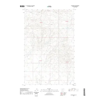
2020 Map of Silver Bow Lake
USGS Topo · Published 2020About this map
Silver Bow Lake and the surrounding high plains of northern Montana define this landscape, where seasonal water sources and prominent geological rises dictate the layout of the land. High points like West Butte and Mid Butte serve as significant landmarks across the rolling terrain, while the branching network of Thirtymile Cr and its tributaries, including Northwest Fork Thirtymile Cr and Br Thirtymile Cr, provide the primary drainage for the region.
Find a feature on this map
17 named features on this map. Tap any name to fly to it.
Don’t see what you’re looking for? This feature index may not catch every label — zoom into the map to look around manually.
Map Details
Editions of this 2020 Silver Bow Lake Map
This is the sole edition of this map. No revisions or reprints were ever made.
Other maps of this area

1904 · Chinook
USGS Topo · 1:62,500

1905 · Harlem
USGS Topo · 1:62,500

1912 · Zurich
USGS Topo · 1:125,000

1913 · Cherry Ridge
USGS Topo · 1:125,000

1953 · Havre
USGS Topo · 1:250,000

1957 · Havre
USGS Topo · 1:250,000

1958 · Havre
USGS Topo · 1:250,000

1984 · Richmond Reservoir
USGS Topo · 1:24,000
1984 · Harlem NW
USGS Topo · 1:24,000
1984 · Silver Bow Lake
USGS Topo · 1:24,000