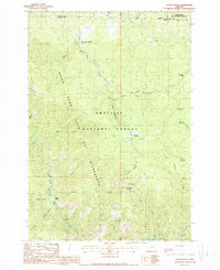
1988 Map of Silver Butte
USGS Topo · Published 1988About this map
The North Fork John Day River and its many tributaries, such as Glade Creek and Ryder Creek, define this area of Grant County in the late 1980s. This survey illustrates a landscape of the Umatilla National Forest and Whitman National Forest where forestry and remote management were the primary human imprints. Markers of federal administration and seasonal use include the Forks Guard Station and recreational sites like Log Table Camp and Silver Spring Camp. The North Fork John Day Wilderness boundary cuts through the center of the map, preserving the drainages around Silver Butte and Wind Rock. Smaller topographic features like Dixson Bar and China Meadow reflect localized naming of the river flats and high meadows, while numerous pack trails provide the only access through the gulches of the Umatilla and Grant County border.
Find a feature on this map
33 named features on this map. Tap any name to fly to it.
Don’t see what you’re looking for? This feature index may not catch every label — zoom into the map to look around manually.
Map Details
Editions of this 1988 Silver Butte Map
This is the sole edition of this map. No revisions or reprints were ever made.
Other maps of this area

1901 · Sumpter
USGS Topo · 1:125,000

1951 · Desolation Butte
USGS Topo · 1:62,500

1953 · Pendleton
USGS Topo · 1:250,000

1955 · Canyon City
USGS Topo · 1:250,000

1956 · Pendleton
USGS Topo · 1:250,000

1959 · Canyon City
USGS Topo · 1:250,000

1965 · Fly Valley
USGS Topo · 1:24,000

1967 · Tower Mtn
USGS Topo · 1:24,000

1967 · Pearson Ridge
USGS Topo · 1:24,000

1972 · Trout Meadows
USGS Topo · 1:24,000