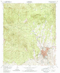
1950 Map of Silver City
USGS Topo · Published 1986About this map
Silver City sits at the base of the Continental Divide, where the high desert meets the wooded slopes of the Gila National Forest. This mid-century survey reveals a mining-and-sanatorium economy in transition, marked by the prominent Cottage Sanatorium and industrial scars at Boston Hill. The landscape is etched with the history of extraction, featuring several Quarries (Aband) and Mill Ruins near the northern boundary. Transportation and community life are anchored by the Atchison Topeka and Santa Fe railroad line terminating at the Depot, while local institutions like St Marys Academy and the Hospital define the urban center. Water management is a critical theme, visible through the Silver City Water Wells and numerous small drainage features like Silva Creek and Little Walnut Creek.
Find a feature on this map
40 named features on this map. Tap any name to fly to it.
Don’t see what you’re looking for? This feature index may not catch every label — zoom into the map to look around manually.
Map Details
Editions of this 1950 Silver City Map
2 editions found

Other maps of this area

1909 · Silver City
USGS Topo · 1:125,000

1947 · Twin Sisters
USGS Topo · 1:24,000

1947 · Fort Bayard
USGS Topo · 1:24,000

1948 · Twin Sisters
USGS Topo · 1:24,000

1949 · Fort Bayard
USGS Topo · 1:24,000

1949 · Hurley West
USGS Topo · 1:24,000

1949 · Circle Mesa
USGS Topo · 1:24,000

1950 · Tyrone
USGS Topo · 1:24,000

1950 · Dorsey Ranch
USGS Topo · 1:24,000

1950 · Wind Mountain
USGS Topo · 1:24,000