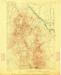
1898 Map of Silver City
USGS Topo · Published 1909About this map
Silver City and the Owyhee Mountains serve as the primary focus of this late nineteenth-century reconnaissance, documenting a period of intense mineral extraction and nascent transportation networks in southwest Idaho. The high-altitude mining district is densely detailed, featuring prominent operations such as the Black Jack Mine, Trade Dollar Mine, and Poorman Mine clustered around the settlements of Dewey and De Lamar. This industrial activity is contrasted by the drainage basin of the Snake River to the northeast, where river-dependent commerce is evidenced by the Warm Springs Ferry and Bernard Ferry. The arrival of the Boise Nampa and Owyhee railroad near Guffey and Walters marks the transition from rugged pack-trail dependence to integrated rail transport. The map also captures smaller peripheral locales like Reynolds and Murphy, which supported the livestock and logistics of the high desert interior.
Find a feature on this map
46 named features on this map. Tap any name to fly to it.
Don’t see what you’re looking for? This feature index may not catch every label — zoom into the map to look around manually.
Map Details
Editions of this 1898 Silver City Map
3 editions found
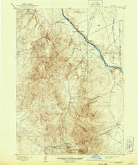
Other maps of this area

1892 · Boise
USGS Topo · 1:125,000

1892 · Bisuka
USGS Topo · 1:125,000

1892 · Silver City
USGS Topo · 1:125,000

1894 · Bisuka
USGS Topo · 1:125,000

1894 · Silver City
USGS Topo · 1:125,000

1897 · Boise
USGS Topo · 1:125,000

1898 · Nampa
USGS Topo · 1:125,000

1898 · Silver City
USGS Topo · 1:125,000

1906 · Mitchell Butte
USGS Topo · 1:125,000

1948 · Sinker Butte
USGS Topo · 1:24,000