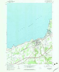
1960 Map of Silver Creek
USGS Topo · Published 1962About this map
Lake Erie defines the northern edge of this coastal landscape, where the waters of Walnut Creek and Silver Creek meet the shoreline. The 1960 revision documents a complex infrastructure of transportation and community life along the lake, particularly centered around the village of Silver Creek. To the east, the Cattaraugus Indian Reservation borders the mouth of Cattaraugus Creek at Sunset Bay, a site marked by seasonal activity at Millers Beach and Wide Beach.
Find a feature on this map
50 named features on this map. Tap any name to fly to it.
Don’t see what you’re looking for? This feature index may not catch every label — zoom into the map to look around manually.
Map Details
Editions of this 1960 Silver Creek Map
2 editions found
Other maps of this area

1899 · Silver Creek
USGS Topo · 1:62,500

1900 · Dunkirk
USGS Topo · 1:62,500

1900 · Cherry Creek
USGS Topo · 1:62,500

1941 · Cherry Creek
USGS Topo · 1:62,500

1943 · Dunkirk
USGS Topo · 1:62,500

1943 · Silver Creek
USGS Topo · 1:24,000
1944 · Angola
USGS Topo · 1:31,680

1944 · Farnham
USGS Topo · 1:31,680

1944 · Silver Creek
USGS Topo · 1:31,680

1954 · Forestville
USGS Topo · 1:24,000