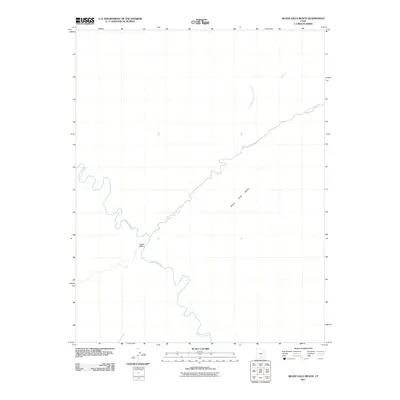
2011 Map of Silver Falls Bench
USGS Topo · Published 2011About this map
Escalante River meanders through this portion of Garfield County, marking a landscape defined by deep drainages and high plateaus. The 2011 survey highlights the intricate desert hydrography, where Harris Wash joins the river amidst a network of seasonal and perennial watercourses. Central to the map is Silver Falls Bench, a significant landform overlooking the path of Silver Falls Creek. This drainage system is further detailed by the North Fork Silver Falls Creek and the Dry Fork, illustrating the complex erosional patterns that characterize the region's topography. The map reveals a wilderness area with very little human infrastructure, focusing instead on the natural orientation of the canyons and the relationship between the elevated benches and the riverbed below.
Find a feature on this map
6 named features on this map. Tap any name to fly to it.
Don’t see what you’re looking for? This feature index may not catch every label — zoom into the map to look around manually.
Map Details
Editions of this 2011 Silver Falls Bench Map
This is the sole edition of this map. No revisions or reprints were ever made.
Other maps of this area

1886 · Escalante
USGS Topo · 1:250,000

1953 · Circle Cliffs 1 SE
USGS Topo · 1:24,000

1953 · Circle Cliffs 4 NW
USGS Topo · 1:24,000

1953 · Circle Cliffs 1 SW
USGS Topo · 1:24,000

1953 · Circle Cliffs 4 NE
USGS Topo · 1:24,000

1953 · Circle Cliffs 4 SW
USGS Topo · 1:24,000

1953 · Moody Creek
USGS Topo · 1:62,500
1953 · Wagon Box Mesa
USGS Topo · 1:62,500

1956 · Escalante
USGS Topo · 1:250,000

1960 · Escalante
USGS Topo · 1:250,000