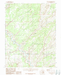
1987 Map of Silver Falls Bench
USGS Topo · Published 1987About this map
The Escalante River carves through this remote stretch of Garfield County, defining a landscape of high benches and deep drainages within the Glen Canyon National Recreation Area. The map reveals the intricate water network of the high desert, where Silver Falls Creek descends through Silver Falls Canyon toward the river valley. Sparse human footprints are recorded at the settlement of Harris and near water sources like Emigrant Spring and Cliff Spring.
Find a feature on this map
19 named features on this map. Tap any name to fly to it.
Don’t see what you’re looking for? This feature index may not catch every label — zoom into the map to look around manually.
Map Details
Editions of this 1987 Silver Falls Bench Map
This is the sole edition of this map. No revisions or reprints were ever made.
Other maps of this area

1886 · Escalante
USGS Topo · 1:250,000

1953 · Circle Cliffs 1 SE
USGS Topo · 1:24,000

1953 · Circle Cliffs 4 NW
USGS Topo · 1:24,000

1953 · Circle Cliffs 1 SW
USGS Topo · 1:24,000

1953 · Circle Cliffs 4 NE
USGS Topo · 1:24,000

1953 · Circle Cliffs 4 SW
USGS Topo · 1:24,000

1953 · Moody Creek
USGS Topo · 1:62,500
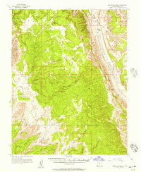
1953 · Wagon Box Mesa
USGS Topo · 1:62,500

1956 · Escalante
USGS Topo · 1:250,000

1960 · Escalante
USGS Topo · 1:250,000