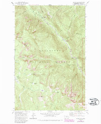
1968 Map of Silver Falls
USGS Topo · Published 1987About this map
Wenatchee National Forest territory dominates this 1960s study, centered on the high-elevation drainage of the Entiat River as it winds through northern Chelan County. The map documents a rugged landscape managed for recreation and resource protection, featuring a series of remote campsites such as Silver Falls Campground, Lake Creek Campground, and Fox Creek Campground. Higher elevations are marked by distinctive peaks including Klone Peak, Kelly Mountain, and Signal Peak, while the valley floors provide crucial summer range at Blue Creek Meadow and Whistling Pig Meadow. The presence of a Forest Service Station, a Gaging Station, and a Weather Station indicates the heavy institutional footprint required for managing this mountain watershed and monitoring the dramatic Silver Falls.
Find a feature on this map
49 named features on this map. Tap any name to fly to it.
Don’t see what you’re looking for? This feature index may not catch every label — zoom into the map to look around manually.
Map Details
Editions of this 1968 Silver Falls Map
Other maps of this area

1899 · Methow
USGS Topo · 1:125,000

1901 · Chelan
USGS Topo · 1:125,000

1901 · Methow
USGS Topo · 1:125,000

1901 · Chiwaukum
USGS Topo · 1:125,000

1902 · Stehekin
USGS Topo · 1:125,000

1904 · Stehekin
USGS Topo · 1:125,000

1904 · Chiwaukum
USGS Topo · 1:125,000

1944 · Lucerne
USGS Topo · 1:62,500

1949 · Lucerne
USGS Topo · 1:62,500

1955 · Concrete
USGS Topo · 1:250,000