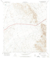
1972 Map of Silver King Canyon
USGS Topo · Published 1974About this map
The Malone Mountains and Quitman Mountains dominate this arid landscape in West Texas, where the terrain is defined by dramatic elevation changes and a network of ephemeral watercourses. Evidence of geological exploration is scattered across the high ground, with numerous Drill Holes and a Mine Drill Hole indicating industrial interest in the vicinity of Silver King Canyon. Human activity in this remote desert environment is focused on water management and border security, as seen by the presence of livestock water sources like Dave Gill Tank and Adobe Tank. A Border Patrol Tower stands as a prominent man-made landmark along the eastern ridges. Low-lying drainage features including Arroyo Balluco and Arroyo Calero carve through the basin, while a Jeep Trail provides the primary means of navigating the interior of this rugged Hudspeth County quadrangle.
Find a feature on this map
17 named features on this map. Tap any name to fly to it.
Don’t see what you’re looking for? This feature index may not catch every label — zoom into the map to look around manually.
Map Details
Editions of this 1972 Silver King Canyon Map
This is the sole edition of this map. No revisions or reprints were ever made.
Other maps of this area

1894 · Fort Hancock
USGS Topo · 1:125,000

1895 · Sierra Blanca
USGS Topo · 1:125,000

1943 · Fort Quitman
USGS Topo · 1:62,500

1943 · Finlay Mountains
USGS Topo · 1:62,500

1948 · Triple Hill
USGS Topo · 1:62,500

1954 · Van Horn
USGS Topo · 1:250,000

1958 · Van Horn
USGS Topo · 1:250,000

1964 · Lasca
USGS Topo · 1:24,000

1964 · Sierra Blanca SW
USGS Topo · 1:24,000
1972 · Campo Grande Mountain
USGS Topo · 1:24,000