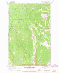
1968 Map of Silver King Mountain
USGS Topo · Published 1971About this map
Helena National Forest terrain dominates this late-1960s survey, showcasing a landscape defined by the drainage of Landers Fork and its numerous tributaries. High-elevation peaks like Silver King Mountain and the Alice Mountains overlook a complex network of pack trails and water bodies. The presence of the Silver King Ranch and the Indian Meadows Guard Station indicates the seasonal human activity typical of these mountain corridors, while the Elk Trail Landing Strip provides a point of backcountry aviation access. Genealogists and researchers may find interest in the specifically named waters such as Keep Cool Lakes, Krohn Lake, and Snowbank Lake. The map details a transition from high summits to the broader basin of Indian Meadows, providing an exact view of the forest infrastructure including a Lookout Tower and a Gravel Pit used for trail or road maintenance.
Find a feature on this map
32 named features on this map. Tap any name to fly to it.
Don’t see what you’re looking for? This feature index may not catch every label — zoom into the map to look around manually.
Map Details
Editions of this 1968 Silver King Mountain Map
2 editions found
Other maps of this area

1889 · Helena
USGS Topo · 1:250,000

1893 · Helena
USGS Topo · 1:250,000

1899 · Helena
USGS Topo · 1:250,000

1903 · Coopers Lake
USGS Topo · 1:125,000

1903 · Helena
USGS Topo · 1:250,000

1943 · Hogan
USGS Topo · 1:125,000

1947 · Butte
USGS Topo · 1:250,000

1955 · Choteau
USGS Topo · 1:250,000

1957 · Choteau
USGS Topo · 1:250,000

1958 · Butte
USGS Topo · 1:250,000