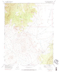
1971 Map of Silver King Well
USGS Topo · Published 1990About this map
High-altitude desert basins and mountain ridges define this 1971 survey of eastern Nevada, where the Egan Range and Schell Creek Range enclose the dramatic Cave Valley. This is a landscape where water is the primary arbiter of human presence, marked by a network of isolated sites like Silver King Well, Griswold Well, and Lewis Well. Evidence of early mining and habitation appears near the eastern foothills, specifically at the Silver King Mine, adjacent to a cluster of Ruins and a lone Grave. The reliance on ephemeral water sources is clear, with labels noting the condition of Wolf Hole Spring and the placement of a Water Tank to support the remote activities of the era. The terrain is navigated primarily by a sparse network of Jeep Trails, underscoring the isolation of the Lincoln and Nye County borderlands.
Find a feature on this map
17 named features on this map. Tap any name to fly to it.
Don’t see what you’re looking for? This feature index may not catch every label — zoom into the map to look around manually.
Map Details
Editions of this 1971 Silver King Well Map
3 editions found
Other maps of this area

1956 · Lund
USGS Topo · 1:250,000

1960 · Lund
USGS Topo · 1:250,000

1969 · Gap Mountain
USGS Topo · 1:24,000

1969 · Sunnyside
USGS Topo · 1:24,000

1971 · Sidehill Spring
USGS Topo · 1:24,000

1971 · Bailey Wash
USGS Topo · 1:24,000
1971 · Timber Mtn Pass NE
USGS Topo · 1:24,000

1971 · Cave Valley Well
USGS Topo · 1:24,000

1971 · Silver King Mtn
USGS Topo · 1:24,000

1971 · Sidehill Pass
USGS Topo · 1:24,000