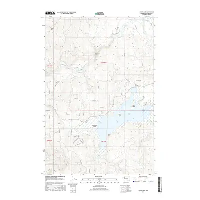
2017 Map of Silver Lake
USGS Topo · Published 2017About this map
Silver Lake and the winding Toutle River define this corner of Cowlitz County, where the water dictates the patterns of local life and transit. The map reveals a cluster of small islands within the lake, including Pete Moore Island, Waldon Island, and Goat Island, alongside the prominent Timber Point. To the north, the terrain rises into the Wilkes Hills and drops through the dramatic Hollywood Gorge, carved by Rock Cr. This area is marked by several early burial sites that anchor the local genealogy, such as Tower Cem, Silver Lake Cem, and Rosin Cem. The network of logging roads and secondary routes like Toutle River Rd and Tower Rd trace the paths through the timberlands and along the tributary waters of Stankey Cr and Salmon Cr.
Find a feature on this map
67 named features on this map. Tap any name to fly to it.
Don’t see what you’re looking for? This feature index may not catch every label — zoom into the map to look around manually.
Map Details
Editions of this 2017 Silver Lake Map
This is the sole edition of this map. No revisions or reprints were ever made.
Other maps of this area

1921 · Kalama
USGS Topo · 1:62,500

1941 · Olequa
USGS Topo · 1:62,500

1942 · Toutle
USGS Topo · 1:62,500

1943 · Pigeon Springs
USGS Topo · 1:62,500

1953 · Hoquiam
USGS Topo · 1:250,000

1953 · Toutle
USGS Topo · 1:62,500

1953 · Castle Rock
USGS Topo · 1:62,500

1953 · Mt. Brynion
USGS Topo · 1:24,000

1953 · Pigeon Springs
USGS Topo · 1:62,500
1953 · Kelso
USGS Topo · 1:24,000