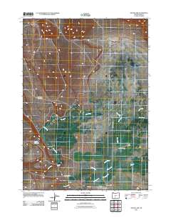
2011 Map of Silver Lake
USGS Topo · Published 2011About this map
The high desert community of Silver Lake serves as the focal point for this 2011 survey of Lake County, Oregon. Concentrated along the intersection of Center St and Lake St, the settlement is anchored by the Silver Lake Post Office and the nearby Silver Lake Cemetery. The surrounding landscape is defined by an extensive network of ranching operations, including the ZX Ranch, Johnson Ranch, and Linebaugh Ranch, which rely on a delicate water system of seasonal creeks and artificial catchments. Braided watercourses like Island Branch and Silver Creek traverse the terrain, while the Crested Reservoir and Lonely Reservoir indicate the vital role of water management in this arid region. The map captures a transition where traditional livestock ranching at Porter Ranch and Cliff Ranch persists amidst a sparse network of county roads like County Hwy 4-10.
Find a feature on this map
22 named features on this map. Tap any name to fly to it.
Don’t see what you’re looking for? This feature index may not catch every label — zoom into the map to look around manually.
Map Details
Editions of this 2011 Silver Lake Map
This is the sole edition of this map. No revisions or reprints were ever made.
Other maps of this area

1955 · Crescent
USGS Topo · 1:250,000

1957 · Crescent
USGS Topo · 1:250,000

1958 · Crescent
USGS Topo · 1:250,000

1968 · Silver Lake
USGS Topo · 1:24,000

1968 · Oatman Flat
USGS Topo · 1:24,000
1968 · Hager Mtn
USGS Topo · 1:24,000
1968 · Bridge Creek Draw
USGS Topo · 1:24,000

1970 · Crescent
USGS Topo · 1:250,000

1979 · Crescent
USGS Topo · 1:100,000
1981 · Tuff Butte
USGS Topo · 1:24,000