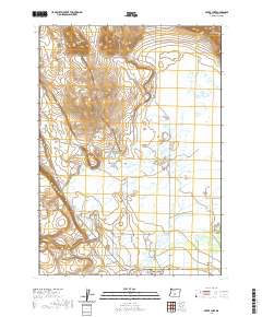
2020 Map of Silver Lake
USGS Topo · Published 2020About this map
Silver Lake sits at the southern edge of this Oregon landscape, where the high desert terrain meets a complex network of seasonal water and marshes. The settlement is anchored by the Silver Lake Cem, serving as a vital point of reference for local family history in Lake County. To the east, the extensive Paulina Marsh dominates the lowlands, fed by a series of drainages including Silver Cr, Buck Cr, and Conley Cr.
Find a feature on this map
20 named features on this map. Tap any name to fly to it.
Don’t see what you’re looking for? This feature index may not catch every label — zoom into the map to look around manually.
Map Details
Editions of this 2020 Silver Lake Map
This is the sole edition of this map. No revisions or reprints were ever made.
Other maps of this area

1955 · Crescent
USGS Topo · 1:250,000

1957 · Crescent
USGS Topo · 1:250,000

1958 · Crescent
USGS Topo · 1:250,000

1968 · Silver Lake
USGS Topo · 1:24,000

1968 · Oatman Flat
USGS Topo · 1:24,000
1968 · Hager Mtn
USGS Topo · 1:24,000
1968 · Bridge Creek Draw
USGS Topo · 1:24,000

1970 · Crescent
USGS Topo · 1:250,000

1979 · Crescent
USGS Topo · 1:100,000
1981 · Tuff Butte
USGS Topo · 1:24,000