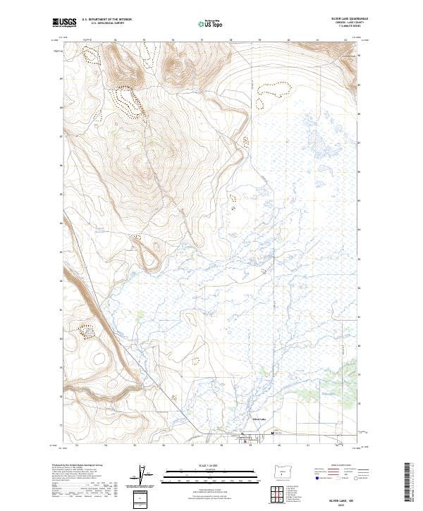
2023 Map of Silver Lake
USGS Topo · Published 2023About this map
Silver Lake serves as the focal point for this high-desert landscape in Lake County, situated where the high plains meet the expansive Paulina Marsh. The settlement pattern centers around the junction of Silver Creek Rd and Center St, with the Silver Lake Cem located just east of the main town site. This area is defined by its complex hydrologic network, where several seasonal watercourses including Buck Creek, Conley Creek, and Bunyard Creek drain toward the marshland floor.
Find a feature on this map
23 named features on this map. Tap any name to fly to it.
Don’t see what you’re looking for? This feature index may not catch every label — zoom into the map to look around manually.
Map Details
Editions of this 2023 Silver Lake Map
This is the sole edition of this map. No revisions or reprints were ever made.
Other maps of this area

1955 · Crescent
USGS Topo · 1:250,000

1957 · Crescent
USGS Topo · 1:250,000

1958 · Crescent
USGS Topo · 1:250,000

1968 · Silver Lake
USGS Topo · 1:24,000

1968 · Oatman Flat
USGS Topo · 1:24,000
1968 · Hager Mtn
USGS Topo · 1:24,000
1968 · Bridge Creek Draw
USGS Topo · 1:24,000

1970 · Crescent
USGS Topo · 1:250,000

1979 · Crescent
USGS Topo · 1:100,000
1981 · Tuff Butte
USGS Topo · 1:24,000