1971 Map of Silver Springs
USGS Topo · Published 1973About this map
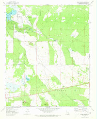
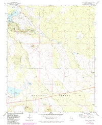
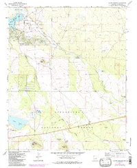
Silver Creek winds through the high plateaus of Navajo County, connecting a network of reservoirs and natural basins including White Mountain Lake, Mexican Lake, and Duck Lake. This 1971 field-checked survey highlights the region's resource management and infrastructure, from the Silver Springs Fish Hatchery to the various water management structures like The Forebay and numerous stock tanks such as Mannerheim Tank and Bluestem Tank.
Find a feature on this map
33 named features on this map. Tap any name to fly to it.
Don’t see what you’re looking for? This feature index may not catch every label — zoom into the map to look around manually.
Map Details
Editions of this 1971 Silver Springs Map
3 editions found
Other maps of this area

1886 · St Johns
USGS Topo · 1:250,000

1886 · Holbrook
USGS Topo · 1:250,000

1892 · St Johns
USGS Topo · 1:250,000

1893 · Holbrook
USGS Topo · 1:250,000

1954 · Holbrook
USGS Topo · 1:250,000

1954 · Saint Johns
USGS Topo · 1:250,000

1957 · Holbrook
USGS Topo · 1:250,000

1957 · Saint Johns
USGS Topo · 1:250,000

1958 · Saint Johns
USGS Topo · 1:250,000

1958 · Holbrook
USGS Topo · 1:250,000