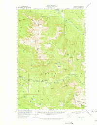
1957 Map of Silverton
USGS Topo · Published 1975About this map
The Sauk River valley and the high peaks of the Cascade Range define this mid-century survey, which documents a landscape transitioning from resource extraction to mountain recreation. Mining activity is preserved in the records of the Bonanza Queen Mine and the St Louis Mine, while the growth of backcountry tourism is evident in a high density of forest camps such as Hemple Creek Campground, Sunnyside Camp, and Deer Creek Camp. The settlement of Silverton sits along the river, near the Silverton-Waldheim County School Camp, serving as a gateway to the steep ridges of Whitehorse Ridge and Wiley Ridge. Massive topographic features like Whitehorse Mtn and the iconic Three Fingers dominate the western half of the map, while the northeastern corner shows the rail-connected community of Darrington. These details show how early logging and mining infrastructure paved the way for the seasonal camping and mountain climbing culture of the late 1950s.
Find a feature on this map
117 named features on this map. Tap any name to fly to it.
Don’t see what you’re looking for? This feature index may not catch every label — zoom into the map to look around manually.
Map Details
Editions of this 1957 Silverton Map

Other maps of this area

1899 · Glacier Peak
USGS Topo · 1:125,000

1899 · Stillaguamish
USGS Topo · 1:125,000

1901 · Glacier Peak
USGS Topo · 1:125,000

1901 · Stilaguamish
USGS Topo · 1:125,000

1902 · Skykomish
USGS Topo · 1:125,000

1905 · Skykomish
USGS Topo · 1:125,000

1921 · Sultan
USGS Topo · 1:125,000

1923 · Sultan
USGS Topo · 1:125,000

1955 · Concrete
USGS Topo · 1:250,000

1956 · Oso
USGS Topo · 1:62,500