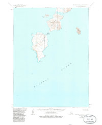
1963 Map of Simeonof Island D-4
USGS Topo · Published 1985About this map
Nagai Island dominates this maritime survey, showcasing the complex coastline of the Shumagin Islands in the early 1960s. The map illustrates a landscape shaped by the sea, where the narrow isthmus of Saddlers Mistake separates the northern and southern reaches of the landmass. This coastal geography provided critical landmarks for navigation and local activity long before modern technology, as evidenced by the prominence of features like Mountain Point at the southern tip. Surrounding the main island, satellite landforms such as John Island to the north and Near Island to the east dot the Pacific Ocean, highlighting the isolated and maritime-dependent nature of this Alaskan region. The 100-foot contour intervals reveal the elevations that served as lookouts and navigation aids for the sparse inhabitants and sailors of the era.
Find a feature on this map
6 named features on this map. Tap any name to fly to it.
Don’t see what you’re looking for? This feature index may not catch every label — zoom into the map to look around manually.
Map Details
Editions of this 1963 Simeonof Island D-4 Map
2 editions found
Other maps of this area

1951 · Stepovak Bay
USGS Topo · 1:250,000

1953 · Port Moller
USGS Topo · 1:250,000

1963 · Port Moller A-1
USGS Topo · 1:63,360

1963 · Port Moller A-2
USGS Topo · 1:63,360
1963 · Simeonof Island D-3
USGS Topo · 1:63,360
1963 · Stepovak Bay A-6
USGS Topo · 1:63,360
1963 · Simeonof Island D-4
USGS Topo · 1:63,360

1963 · Simeonof Island
USGS Topo · 1:250,000

1963 · Stepovak Bay
USGS Topo · 1:250,000

1967 · Simeonof Island
USGS Topo · 1:250,000