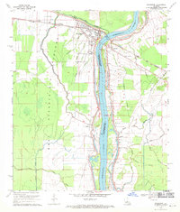
1969 Map of Simmesport
USGS Topo · Published 1970About this map
The Atchafalaya River serves as the central artery for this late-1960s landscape, marking the boundary between Avoyelles Parish and Pointe Coupee Parish. The town of Simmesport sits at a critical junction where the river meets Bayou des Glaises, its layout defined by the heavy infrastructure of the West Atchafalaya Floodway and the Texas and Louisiana Pacific and Arkansas Railroad. Beyond the main settlement, the map reveals a rural network of small communities and social centers, including Dunbar High Sch and numerous community churches like Mt Calvary Ch and Sunrise Ch. To the south and east, the terrain becomes a complex web of waterways including Moreau Bayou and Marine Bayou, illustrating the reclaimed alluvial land characteristic of the basin's drainage patterns and agricultural development.
Find a feature on this map
36 named features on this map. Tap any name to fly to it.
Don’t see what you’re looking for? This feature index may not catch every label — zoom into the map to look around manually.
Map Details
Editions of this 1969 Simmesport Map
2 editions found
Other maps of this area

1939 · Artonish
USGS Topo · 1:62,500

1941 · Voorhies
USGS Topo · 1:62,500

1941 · Batchelor
USGS Topo · 1:62,500

1953 · Natchez
USGS Topo · 1:250,000

1954 · Artonish
USGS Topo · 1:62,500

1954 · Baton Rouge
USGS Topo · 1:250,000

1955 · Artonish
USGS Topo · 1:62,500

1955 · Batchelor
USGS Topo · 1:62,500

1955 · Odenburg
USGS Topo · 1:62,500

1956 · Natchez
USGS Topo · 1:250,000