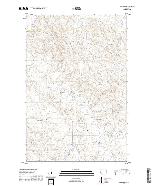
2024 Map of Simons Butte
USGS Topo · Published 2024About this map
The Evangelical Lutheran Friedendal Cem sits as a quiet focal point in this portion of the Montana prairie, marking the presence of early religious and community ties along the border of Dawson and Prairie counties. The landscape is defined by an intricate network of drainages and topographical features, including Simons Butte and the winding course of Cabin Creek. Named coulees and gulches like Roehl Coulee, Buckskin Gulch, and Bull Coulee reveal the complex erosion patterns and water-scarce geography typical of this region.
Find a feature on this map
28 named features on this map. Tap any name to fly to it.
Don’t see what you’re looking for? This feature index may not catch every label — zoom into the map to look around manually.
Map Details
Editions of this 2024 Simons Butte Map
This is the sole edition of this map. No revisions or reprints were ever made.
Other maps of this area

1953 · Miles City
USGS Topo · 1:250,000

1957 · Miles City
USGS Topo · 1:250,000

1958 · Miles City
USGS Topo · 1:250,000

1966 · Marsh SW
USGS Topo · 1:24,000

1967 · Marsh
USGS Topo · 1:24,000

1967 · Hoyt
USGS Topo · 1:24,000
1967 · Upper Magpie Reservoir
USGS Topo · 1:24,000

1981 · Mildred NE
USGS Topo · 1:24,000

1981 · Dorothy Draw
USGS Topo · 1:24,000
1981 · Mildred
USGS Topo · 1:24,000