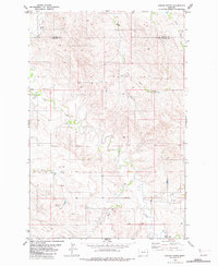
1982 Map of Simons Butte
USGS Topo · Published 1982About this map
Simons Butte stands as a prominent landmark in this eastern Montana landscape, where the high plains meet a complex network of drainage systems. Located along the boundary of Dawson Co and Prairie Co, the area is defined by the intricate winding of Cabin Creek and its many tributaries, including Hay Creek and Ash Creek. The map documents a sparsely populated ranching or agricultural environment during the early 1980s, marked by scattered water sources such as a Flowing Well and several generic Well sites essential for life in this arid climate. A small Cem is located near the center of the sheet, providing a primary point of interest for genealogists or local historians tracing early inhabitants. The drainage patterns of Huey Creek and its South Fork further illustrate the erosion-carved topography that characterizes this part of the state.
Find a feature on this map
12 named features on this map. Tap any name to fly to it.
Don’t see what you’re looking for? This feature index may not catch every label — zoom into the map to look around manually.
Map Details
Editions of this 1982 Simons Butte Map
This is the sole edition of this map. No revisions or reprints were ever made.
Other maps of this area

1953 · Miles City
USGS Topo · 1:250,000

1957 · Miles City
USGS Topo · 1:250,000

1958 · Miles City
USGS Topo · 1:250,000

1966 · Marsh SW
USGS Topo · 1:24,000

1967 · Marsh
USGS Topo · 1:24,000

1967 · Hoyt
USGS Topo · 1:24,000
1967 · Upper Magpie Reservoir
USGS Topo · 1:24,000

1981 · Mildred NE
USGS Topo · 1:24,000

1981 · Dorothy Draw
USGS Topo · 1:24,000
1981 · Mildred
USGS Topo · 1:24,000