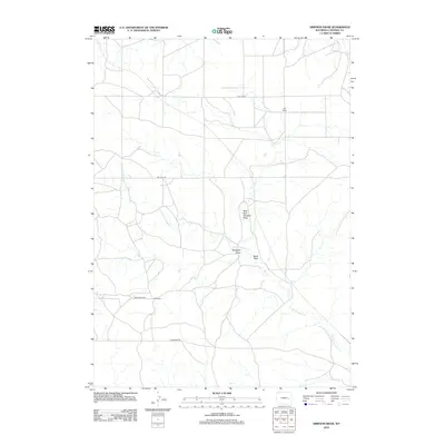
2012 Map of Simpson Draw
USGS Topo · Published 2012About this map
The high plains of Converse County are defined by a network of ephemeral watercourses and large agricultural holdings as seen in this 2012 survey. Significant family-named landmarks including Hall Ranch and York Ranch anchor the local geography, connected by a system of rural routes such as Flat Top Rd and Bill Hall Rd. The drainage patterns of the area are intricately mapped, showing how Sand Draw and West Fork Simpson Draw carve through the terrain toward the W Fork Shawnee Cr. This map reveals a landscape where road names often reflect the long-standing ranching operations that have shaped the region's history, providing a detailed record of land use and seasonal water flow in the Wyoming interior.
Find a feature on this map
12 named features on this map. Tap any name to fly to it.
Don’t see what you’re looking for? This feature index may not catch every label — zoom into the map to look around manually.
Map Details
Editions of this 2012 Simpson Draw Map
This is the sole edition of this map. No revisions or reprints were ever made.
Other maps of this area

1949 · Shawnee
USGS Topo · 1:24,000

1949 · Irvine
USGS Topo · 1:24,000

1949 · Clausen Ranch
USGS Topo · 1:24,000

1949 · Orin
USGS Topo · 1:24,000

1949 · Antelope Creek
USGS Topo · 1:24,000

1950 · Clausen Ranch
USGS Topo · 1:24,000

1950 · Orin
USGS Topo · 1:24,000
1950 · Irvine
USGS Topo · 1:24,000
1950 · Antelope Creek
USGS Topo · 1:24,000

1950 · Shawnee
USGS Topo · 1:24,000