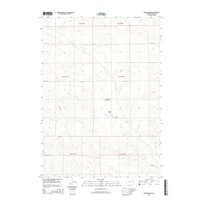
2015 Map of Simpson Draw
USGS Topo · Published 2015About this map
Gillespie Reservoir anchors the southeastern landscape of this Converse County quadrangle, where the ephemeral drainage systems characteristic of the Wyoming high plains define the terrain. The network of waterways includes Simpson Draw and its tributary, the West Fork Simpson Draw, which carve through the undulating topography alongside W Fork Shawnee Cr. This 2015 survey illustrates a rural ranching environment structured by a grid of range and township lines, including t33n r69w and t34n r70w. Transportation across this expansive territory relies on gravel and dirt routes such as York Ranch Rd and Flat Top Rd, reflecting the sparse but enduring human footprint in the region. The map provides a detailed view of the natural water management through features like Sand Draw, essential for understanding the historical land use and hydrologic patterns of the American West.
Find a feature on this map
17 named features on this map. Tap any name to fly to it.
Don’t see what you’re looking for? This feature index may not catch every label — zoom into the map to look around manually.
Map Details
Editions of this 2015 Simpson Draw Map
This is the sole edition of this map. No revisions or reprints were ever made.
Other maps of this area

1949 · Shawnee
USGS Topo · 1:24,000

1949 · Irvine
USGS Topo · 1:24,000

1949 · Clausen Ranch
USGS Topo · 1:24,000

1949 · Orin
USGS Topo · 1:24,000

1949 · Antelope Creek
USGS Topo · 1:24,000

1950 · Clausen Ranch
USGS Topo · 1:24,000

1950 · Orin
USGS Topo · 1:24,000
1950 · Irvine
USGS Topo · 1:24,000
1950 · Antelope Creek
USGS Topo · 1:24,000

1950 · Shawnee
USGS Topo · 1:24,000