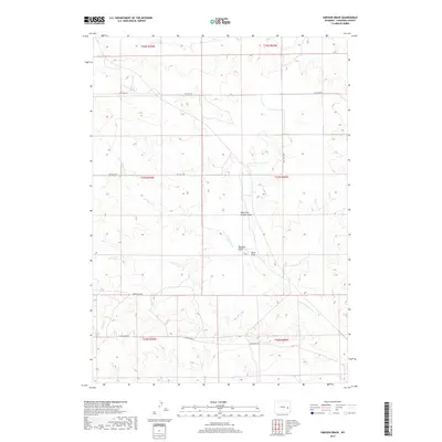
2017 Map of Simpson Draw
USGS Topo · Published 2017About this map
W Fork Shawnee Cr and West Fork Simpson Draw carve through this section of the Wyoming high plains, defining a landscape marked by intermittent drainage and ranching infrastructure. This survey captures a remote portion of Converse County where water sources like Sand Draw and Sand Cr dictate the layout of rural routes. Long-established cattle trails and access ways have evolved into a network of thoroughfares, including Flat Top Rd and York Ranch Rd, which connect the disparate sections of the Public Land Survey System. The map illustrates the 2017 geography of this region, emphasizing the importance of ephemeral creeks like Smith Cr in an environment where natural boundaries are shaped by the flow of seasonal water through the draws.
Find a feature on this map
16 named features on this map. Tap any name to fly to it.
Don’t see what you’re looking for? This feature index may not catch every label — zoom into the map to look around manually.
Map Details
Editions of this 2017 Simpson Draw Map
This is the sole edition of this map. No revisions or reprints were ever made.
Other maps of this area

1949 · Shawnee
USGS Topo · 1:24,000

1949 · Irvine
USGS Topo · 1:24,000

1949 · Clausen Ranch
USGS Topo · 1:24,000

1949 · Orin
USGS Topo · 1:24,000

1949 · Antelope Creek
USGS Topo · 1:24,000

1950 · Clausen Ranch
USGS Topo · 1:24,000

1950 · Orin
USGS Topo · 1:24,000
1950 · Irvine
USGS Topo · 1:24,000
1950 · Antelope Creek
USGS Topo · 1:24,000

1950 · Shawnee
USGS Topo · 1:24,000