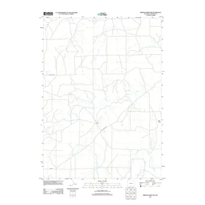
2012 Map of Simpson Draw NW
USGS Topo · Published 2012About this map
Walker Cr and its various tributaries, including the W Fork Walker Cr and S Fork Walker Cr, weave through this high plains landscape in Converse County. The area is defined by a remote network of ranching infrastructure and drainage systems, where isolated operations like the Lebar Ranch sit amidst the arid terrain. The map reveals the critical importance of water management in this environment, as shown by the prominent Miller Draw and the course of Willow Cr. A sparse grid of local thoroughfares such as Walker Creek Rd, Eberspecher Rd, and Reese Rd provides the only access across these expansive parcels. This 2012 survey serves as a detailed record of the contemporary rural Wyoming landscape, documenting how modern ranching properties continue to be shaped by the region’s distinct hydrological features.
Find a feature on this map
9 named features on this map. Tap any name to fly to it.
Don’t see what you’re looking for? This feature index may not catch every label — zoom into the map to look around manually.
Map Details
Editions of this 2012 Simpson Draw NW Map
This is the sole edition of this map. No revisions or reprints were ever made.
Other maps of this area

1949 · Clausen Ranch
USGS Topo · 1:24,000

1949 · Antelope Creek
USGS Topo · 1:24,000

1950 · Clausen Ranch
USGS Topo · 1:24,000
1950 · Antelope Creek
USGS Topo · 1:24,000

1954 · Torrington
USGS Topo · 1:250,000

1955 · Newcastle
USGS Topo · 1:250,000

1958 · Torrington
USGS Topo · 1:250,000

1958 · Newcastle
USGS Topo · 1:250,000

1959 · Bill
USGS Topo · 1:62,500
1970 · The Park
USGS Topo · 1:24,000