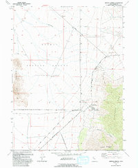
1993 Map of Simpson Springs
USGS Topo · Published 1993About this map
The Simpson Springs Pony Express Station serves as the central historical anchor of this desert landscape, situated at the base of the Simpson Mts. This location highlights the intersection of 19th-century transit and 20th-century military utility, as the historic Pony Express and Overland Stage Route cuts directly through the northern portion of the Dugway Proving Ground. The map illustrates a stark divide between the open terrain of Government Creek and the restricted military zones, providing a clear record of land use in this part of Tooele County.
Find a feature on this map
18 named features on this map. Tap any name to fly to it.
Don’t see what you’re looking for? This feature index may not catch every label — zoom into the map to look around manually.
Map Details
Editions of this 1993 Simpson Springs Map
This is the sole edition of this map. No revisions or reprints were ever made.
Other maps of this area

1885 · Sevier Desert
USGS Topo · 1:250,000

1885 · Tooele Valley
USGS Topo · 1:250,000

1953 · Tooele
USGS Topo · 1:250,000

1953 · Delta
USGS Topo · 1:250,000

1954 · Camels Back Ridge NW
USGS Topo · 1:24,000

1955 · Camels Back Ridge SW
USGS Topo · 1:24,000

1955 · Simpson Springs
USGS Topo · 1:24,000

1955 · Indian Peaks
USGS Topo · 1:24,000

1955 · Indian Springs
USGS Topo · 1:24,000

1955 · Camels Back Ridge NE
USGS Topo · 1:24,000