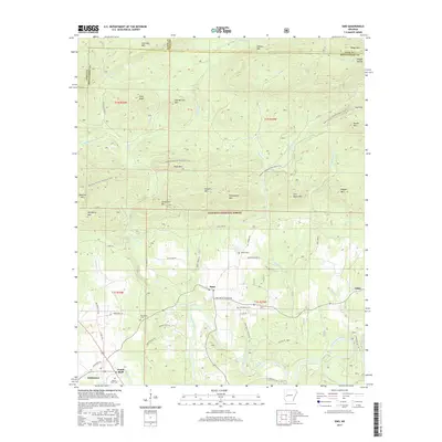
2017 Map of Sims
USGS Topo · Published 2017About this map
Sims and Pencil Bluff serve as the primary focal points in this section of the Ouachita National Forest, where the terrain is defined by a dense network of ridges and watercourses. The Ouachita River winds through the southern portion of the quadrangle, joined by numerous tributaries such as Fiddlers Creek and Rainy Creek. For local historians and genealogists, the map reveals several community landmarks, including Macedonia Cemetery, Barber Cemetery, and Lone Valley Cemetery, which are connected by a web of rural routes like Long Valley Church Road. Higher elevations are marked by prominent summits like Pilot Knob, Stovall Mountain, and Chalybeate Mountain. Outdoor recreation is evidenced by the Ouachita National Recreation Trail, which traverses the central ridges including Rock Row. This landscape reflects a rural Arkansas pattern of small settlements tied to both the river valleys and the managed timberlands of the national forest.
Find a feature on this map
68 named features on this map. Tap any name to fly to it.
Don’t see what you’re looking for? This feature index may not catch every label — zoom into the map to look around manually.
Map Details
Editions of this 2017 Sims Map
This is the sole edition of this map. No revisions or reprints were ever made.
Other maps of this area

1887 · Mount Ida #2
USGS Topo · 1:62,500

1890 · Mount Ida
USGS Topo · 1:125,000

1955 · Little Rock
USGS Topo · 1:250,000

1956 · Little Rock
USGS Topo · 1:250,000

1959 · Oden
USGS Topo · 1:62,500

1959 · Mount Ida
USGS Topo · 1:62,500

1960 · Little Rock
USGS Topo · 1:250,000

1960 · Gravelly
USGS Topo · 1:62,500
1960 · Parks
USGS Topo · 1:62,500

1964 · Little Rock
USGS Topo · 1:250,000