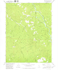
1979 Map of Sims Mountain
USGS Topo · Published 1979About this map
The South Fork Trinity River carves a deep path through the eastern portion of this terrain, marking the division between Humboldt and Trinity counties. This 1970s landscape within the Six Rivers National Forest is defined by steep relief, rising from the river to peaks like Sims Mountain and Bennett Peak. The map reveals a network of high-elevation trails and remote outposts, including the South Fork Mountain Trail and the South Fork Trail, which follow the primary ridges. Human presence is concentrated around isolated sites such as Margarita Ranch, Lake Mountain Ranch, and the Dan East Cabin. Notable landmarks for local history include Mule Bridge crossing the river and several springs and openings, such as Waferbarrel Opening and Black Fox Spring, which indicate the critical importance of water sources in this high-country environment.
Find a feature on this map
48 named features on this map. Tap any name to fly to it.
Don’t see what you’re looking for? This feature index may not catch every label — zoom into the map to look around manually.
Map Details
Editions of this 1979 Sims Mountain Map
This is the sole edition of this map. No revisions or reprints were ever made.
Other maps of this area

1909 · Big Bar
USGS Topo · 1:96,000

1914 · Pilot Creek
USGS Topo · 1:62,500

1915 · Big Bar and Vicinity
USGS Topo · 1:250,000

1922 · China Flat
USGS Topo · 1:62,500

1951 · Pilot Creek
USGS Topo · 1:62,500

1951 · Hyampom
USGS Topo · 1:62,500

1951 · Ironside Mountain
USGS Topo · 1:62,500

1952 · Willow Creek
USGS Topo · 1:62,500

1958 · Redding
USGS Topo · 1:250,000
1977 · Board Camp Mtn
USGS Topo · 1:24,000