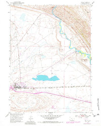
1953 Map of Sinclair
USGS Topo · Published 1982About this map
The town of Sinclair, Wyoming, is defined by its industrial landscape and vital transportation links in this mid-century survey. Dominated by a massive oil Refinery and supported by infrastructure such as a Filtration Plant and Sewage Disposal Plant, the settlement reflects the region's mid-century energy development. The Union Pacific railroad cuts directly through the heart of the community, underscoring the town's importance as a logistics hub. Nearby, Sinclair Airfield and a CAA Relay Station highlight the era's growing aviation and communications network.
Find a feature on this map
21 named features on this map. Tap any name to fly to it.
Don’t see what you’re looking for? This feature index may not catch every label — zoom into the map to look around manually.
Map Details
Editions of this 1953 Sinclair Map
3 editions found
Other maps of this area

1893 · Fort Steele
USGS Topo · 1:125,000

1914 · Walcott
USGS Topo · 1:62,500

1953 · Sinclair
USGS Topo · 1:24,000

1953 · Rawlins
USGS Topo · 1:24,000

1953 · Lone Haystack Mountain
USGS Topo · 1:24,000

1953 · Rawlins NW
USGS Topo · 1:24,000

1954 · Rawlins
USGS Topo · 1:250,000

1955 · Savage Ranch
USGS Topo · 1:24,000

1956 · Bolten Ranch
USGS Topo · 1:62,500

1958 · Rawlins
USGS Topo · 1:250,000