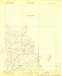
1912 Map of Singer Creek
USGS Topo · Published 1922About this map
Tehama Co Butte Co serves as a prominent dividing line in this 1912 preliminary survey of the northern Sacramento Valley foothills. The landscape is defined by a dense network of intermittent drainage systems, including Singer Creek and Rattlesnake Creek, which cut through the terrain as they flow toward the valley floor. This specific sheet captures the area during a transitional period of agricultural development, indicated by the isolated presence of the Liveoak School near the Mt Diablo Meridian. The mapping of Brush Creek and Camel Creek illustrates the early 20th-century focus on water resources and land division in this unsurveyed portion of Northern California. Because it was issued as a preliminary edition, the map emphasizes natural watercourses and section lines over dense infrastructure, providing a clear look at the original drainage patterns of Pine Creek before more extensive regional irrigation altered the local hydrology.
Find a feature on this map
10 named features on this map. Tap any name to fly to it.
Don’t see what you’re looking for? This feature index may not catch every label — zoom into the map to look around manually.
Map Details
Editions of this 1912 Singer Creek Map
2 editions found

Other maps of this area

1886 · Lassen Peak
USGS Topo · 1:250,000

1890 · Red Bluff
USGS Topo · 1:250,000

1891 · Chico
USGS Topo · 1:125,000

1892 · Lassen Peak
USGS Topo · 1:250,000

1893 · Chico
USGS Topo · 1:125,000

1894 · Lassen Peak
USGS Topo · 1:250,000

1894 · Red Bluff
USGS Topo · 1:250,000

1895 · Chico
USGS Topo · 1:125,000

1904 · Vina
USGS Topo · 1:62,500

1905 · Tehama
USGS Topo · 1:62,500