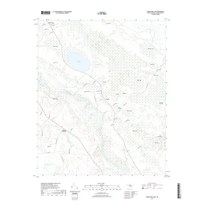
2019 Map of Singletary Lake
USGS Topo · Published 2019About this map
The Cape Fear River carves a winding path through this corner of Bladen County, defining a landscape dominated by the Carolina Bays — distinct elliptical depressions that form a complex network of wetlands and lakes. Singletary Lake and White Lake stand as the most prominent of these geological features, surrounded by dozens of smaller, vegetation-filled basins including Old House Bay, Kings Bay, and Bandeau Bay. These bays and the sprawling Colly Swamp created a challenging environment for early settlement, which is clustered here in small communities like Lagoon and Bladen Springs. Family history is preserved in scattered burial grounds such as the Smith Cemeteries, Atkinson Cem, and Beatty Cem. Evidence of rural infrastructure remains visible through landmarks like Bevans Bridge and the overlook at Walkers Bluff, showing how residents navigated this watery terrain.
Find a feature on this map
66 named features on this map. Tap any name to fly to it.
Don’t see what you’re looking for? This feature index may not catch every label — zoom into the map to look around manually.
Map Details
Editions of this 2019 Singletary Lake Map
This is the sole edition of this map. No revisions or reprints were ever made.
Other maps of this area

1953 · Florence
USGS Topo · 1:250,000

1954 · Florence
USGS Topo · 1:250,000

1954 · White Lake
USGS Topo · 1:62,500

1954 · Bolton
USGS Topo · 1:62,500

1955 · Whiteville
USGS Topo · 1:62,500

1955 · Elizabethtown
USGS Topo · 1:62,500

1982 · Elizabethtown
USGS Topo · 1:100,000
1986 · Singletary Lake
USGS Topo · 1:24,000
1986 · Kelly
USGS Topo · 1:24,000
1986 · Council
USGS Topo · 1:24,000