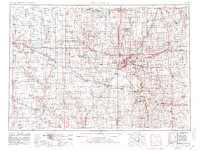
1955 Map of Sioux Falls
USGS Topo · Published 1981About this map
The Sioux Falls metropolitan area serves as the anchor for this mid-century survey, where the borders of South Dakota, Minnesota, and Iowa converge. The landscape is defined by the drainage of the Big Sioux River and its tributaries, including Skunk Creek and Split Rock Creek. Rail transportation is a dominant feature of the regional economy, with the lines of the Chicago and North Western and the Chicago Milwaukee St Paul and Pacific creating a dense web between established agricultural hubs like Madison, Luverne, and Rock Rapids.
Find a feature on this map
127 named features on this map. Tap any name to fly to it.
Don’t see what you’re looking for? This feature index may not catch every label — zoom into the map to look around manually.
Map Details
Editions of this 1955 Sioux Falls Map
3 editions found

Other maps of this area

1897 · Canton
USGS Topo · 1:125,000

1898 · Olivet
USGS Topo · 1:125,000

1898 · Parker
USGS Topo · 1:125,000

1898 · Huron
USGS Topo · 1:125,000

1898 · Elk Point
USGS Topo · 1:125,000

1899 · Mitchell
USGS Topo · 1:125,000

1899 · Alexandria
USGS Topo · 1:125,000

1899 · De Smet
USGS Topo · 1:125,000

1900 · Canton
USGS Topo · 1:125,000

1901 · Elk Point
USGS Topo · 1:125,000