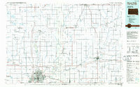
1985 Map of Sioux Falls
USGS Topo · Published 1985About this map
Sioux Falls serves as the metropolitan anchor of this multi-state region, where the Big Sioux River carves through the landscape. By the mid-1980s, the city’s educational and transportation infrastructure was well established, featuring institutions like Augustana College and Sioux Falls College, alongside the regional hub at Foss Field. North of the city, the EROS Data Center represents a significant technological presence in the rural landscape of Minnehaha County.
Find a feature on this map
103 named features on this map. Tap any name to fly to it.
Don’t see what you’re looking for? This feature index may not catch every label — zoom into the map to look around manually.
Map Details
Editions of this 1985 Sioux Falls Map
2 editions found
Other maps of this area

1897 · Canton
USGS Topo · 1:125,000

1898 · Parker
USGS Topo · 1:125,000

1900 · Canton
USGS Topo · 1:125,000

1953 · Watertown
USGS Topo · 1:250,000

1953 · New Ulm
USGS Topo · 1:250,000

1954 · Fairmont
USGS Topo · 1:250,000

1955 · Sioux Falls
USGS Topo · 1:250,000

1957 · New Ulm
USGS Topo · 1:250,000

1958 · New Ulm
USGS Topo · 1:250,000

1958 · Sioux Falls
USGS Topo · 1:250,000