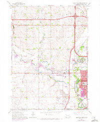
1962 Map of Sioux Falls West
USGS Topo · Published 1972About this map
Skunk Creek and Willow Creek converge in the western outskirts of the city, defining the drainage patterns of Wayne and Benton townships during the early 1960s. The landscape is a transition between the rural prairie settlements of Ellis and Ellis Corner and the expanding urban footprint of Sioux Falls. This era shows the heavy influence of the railroad on local development, with the Chicago and North Western and Burlington Northern lines cutting through the terrain. Civic and social life is anchored by a dense network of country schools, including Foster Sch, Lackey Sch, and Spring Valley Sch, alongside the Sunnycrest Ch and the prominent V A Hospital complex. In the northeast, Foss Field and the Elmwood Golf Course mark the edges of the city's growth into Mapleton township.
Find a feature on this map
35 named features on this map. Tap any name to fly to it.
Don’t see what you’re looking for? This feature index may not catch every label — zoom into the map to look around manually.
Map Details
Editions of this 1962 Sioux Falls West Map

Other maps of this area

1897 · Canton
USGS Topo · 1:125,000

1900 · Canton
USGS Topo · 1:125,000

1955 · Sioux Falls
USGS Topo · 1:250,000

1958 · Sioux Falls
USGS Topo · 1:250,000

1962 · Renner
USGS Topo · 1:24,000

1962 · Harrisburg
USGS Topo · 1:24,000

1962 · Sioux Falls East
USGS Topo · 1:24,000

1962 · Tea
USGS Topo · 1:24,000

1962 · Hartford South
USGS Topo · 1:24,000

1962 · Lennox NW
USGS Topo · 1:24,000
Featured Places
- Sioux Falls, SD
- Wayne Township, SD
- Delapre Township, SD
- Sioux Falls Township, Sioux Falls
- Reppert Addition, SD