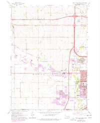
1962 Map of Sioux Falls West
USGS Topo · Published 1977About this map
Sioux Falls and its westward expansion dominate this survey, which details the city’s post-war suburban growth and industrial infrastructure. The landscape is defined by the convergence of the Big Sioux River and Skunk Creek, with the city's western reach nearing the settlement of Ellis. Public institutions and community landmarks are prominently mapped, including the VA Hospital, Childrens Home, and O'Gorman High Sch. The map records a transition from rural townships like Benton and Wayne to a more developed urban fringe, marked by the extensive footprint of Foss Field (Sioux Falls Municipal Airport) and numerous Gravel Pits along the riverbanks. Local history is preserved in rural school sites such as Spring Valley Sch and Foster Sch, while the presence of the Chicago and North Western and Burlington Northern railroads highlights the enduring importance of rail transport to the region's economy.
Find a feature on this map
39 named features on this map. Tap any name to fly to it.
Don’t see what you’re looking for? This feature index may not catch every label — zoom into the map to look around manually.
Map Details
Editions of this 1962 Sioux Falls West Map

Other maps of this area

1897 · Canton
USGS Topo · 1:125,000

1900 · Canton
USGS Topo · 1:125,000

1955 · Sioux Falls
USGS Topo · 1:250,000

1958 · Sioux Falls
USGS Topo · 1:250,000

1962 · Renner
USGS Topo · 1:24,000

1962 · Harrisburg
USGS Topo · 1:24,000

1962 · Sioux Falls East
USGS Topo · 1:24,000

1962 · Tea
USGS Topo · 1:24,000

1962 · Hartford South
USGS Topo · 1:24,000

1962 · Lennox NW
USGS Topo · 1:24,000
Featured Places
- Sioux Falls, SD
- Wayne Township, SD
- Delapre Township, SD
- Sioux Falls Township, Sioux Falls
- Reppert Addition, SD