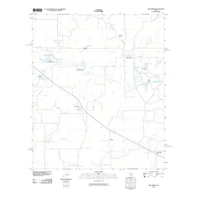
2010 Map of Sipe Springs
USGS Topo · Published 2010About this map
Sipe Springs serves as the primary community hub on this landscape, located at the junction of several county roads and farm-to-market routes. The terrain is defined by a dense network of intermittent streams and water management features, including the Sipe Springs Creek and Nanny Branch. Local history is anchored by the Sipe Springs Cemetery and Parker Cemetery, while the presence of named bodies of water like Railroad Lake, North Gibson Lake, and Highway Lake points to a rural economy built around water storage and land management. Down at the southeastern edge, the settlement of Stag Creek sits along its namesake waterway, Stag Creek, illustrating the classic Texas pattern of naming small communities for the local creek. Soil conservation efforts are highly visible through multiple reservoirs and dams, reflecting 20th-century land reclamation practices across Comanche County.
Find a feature on this map
47 named features on this map. Tap any name to fly to it.
Don’t see what you’re looking for? This feature index may not catch every label — zoom into the map to look around manually.
Map Details
Editions of this 2010 Sipe Springs Map
This is the sole edition of this map. No revisions or reprints were ever made.
Other maps of this area

1889 · Brownwood
USGS Topo · 1:125,000

1894 · Eastland
USGS Topo · 1:125,000

1894 · Brownwood
USGS Topo · 1:125,000

1954 · Brownwood
USGS Topo · 1:250,000

1954 · Abilene
USGS Topo · 1:250,000

1958 · Abilene
USGS Topo · 1:250,000
1966 · May
USGS Topo · 1:24,000

1966 · Star Mountain
USGS Topo · 1:24,000

1966 · Sipe Springs
USGS Topo · 1:24,000
1966 · Rising Star
USGS Topo · 1:24,000