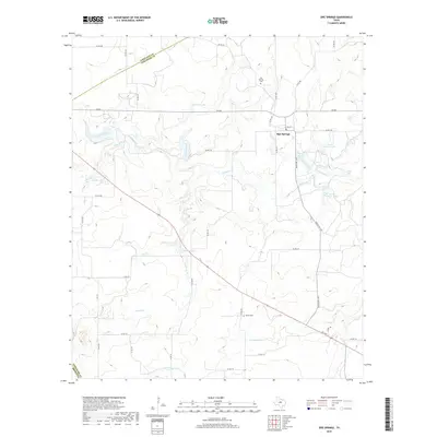
2019 Map of Sipe Springs
USGS Topo · Published 2019About this map
Sipe Springs sits at the heart of this North Texas landscape where the boundaries of Eastland and Comanche counties meet. The settlement is flanked by agricultural lands and a series of managed water bodies, including the descriptively named Railroad Lake and Highway Lake. This 2019 survey documents a rural environment defined by its drainage systems, where Copperas Creek and its many tributaries like Keys Br and Nanny Br carve through the terrain. For genealogists and local historians, the map identifies critical landmarks such as the Sipe Springs Cem and Parker Cem, which serve as vital anchors for tracing the area's early residents. The road network, including FM 587 and Ranch RD 1477, connects these small-scale landmarks, revealing the modern persistence of a community shaped by its proximity to local creeks and the small reservoirs of the North Gibson Lake and South Gibson Lake areas.
Find a feature on this map
45 named features on this map. Tap any name to fly to it.
Don’t see what you’re looking for? This feature index may not catch every label — zoom into the map to look around manually.
Map Details
Editions of this 2019 Sipe Springs Map
This is the sole edition of this map. No revisions or reprints were ever made.
Other maps of this area

1889 · Brownwood
USGS Topo · 1:125,000

1894 · Eastland
USGS Topo · 1:125,000

1894 · Brownwood
USGS Topo · 1:125,000

1954 · Brownwood
USGS Topo · 1:250,000

1954 · Abilene
USGS Topo · 1:250,000

1958 · Abilene
USGS Topo · 1:250,000
1966 · May
USGS Topo · 1:24,000

1966 · Star Mountain
USGS Topo · 1:24,000

1966 · Sipe Springs
USGS Topo · 1:24,000
1966 · Rising Star
USGS Topo · 1:24,000